Alas, it’s raining. Ugh. Although we’re here in South Wales to hike some of the Pembrokeshire Coastal Path, today is definitely not the day! So we’re off to St. David’s Cathedral, which is located nearby on the most westerly point of Wales.
Time for a little history, of which St. David’s has seen a lot! It goes back almost 15 centuries. St. David (patron saint of Wales and one of the earliest identifiable figures of Welsh history) founded a strict monastic community here sometime before his death in 589. The community survived frequent plunder by Vikings over the next 500 years – a number of bishops were killed – while steadily achieving renown as a religious and intellectual center. After William the Conqueror subjugated England, he visited St. David’s as a pilgrim in 1081. In 1123 the Pope decreed that “Two pilgrimages to St. Davids is equal to one to Rome, and three pilgrimages to one to Jerusalem”, making St. David’s one of the most important shrines of medieval Christendom. A new cathedral was quickly constructed in 1131. King Henry II visited in  1171, leading to an increase in pilgrimage and necessitating a larger cathedral; the present cathedral was begun in 1181 and swiftly completed. King Edward I conquered Wales (post Northern Wales I: Conwy) and visited St. David’s in 1284. In 1328 the reigning bishop of St. David’s started work on the impressive Bishop’s Palace, shown in the illustration above. St. David’s Cathedral was further modified over time, with St. Mary’s College and cloister added in 1365 and the Holy Trinity Chapel in 1509. An inadequate foundation and the effect of an earthquake in the mid 1200’s caused the walls of the west nave to lean outwards; ultimately the ceiling was replaced with Irish oak, in 1530. In 1648 during England’s Civil War, Cromwell’s forces all but destroyed the Cathedral and stripped the lead from the Bishop’s Palace roof. 200 years later, in 1862, the Cathedral was restored.
 Enough history -let’s take a look at this very interesting cathedral! Its overall appearance is nicely captured in the picture to the left, which is a magnification from the illustration above. The entrance gate to the compound is in the upper right corner; the wall in the illustration no longer exists, but the massive gate, dating to the 1300’s, remains, as shown below. After passing through the gate, your way down to the cathedral takes you past a cemetery (conventional wisdom said the closer you were buried to a church, the better your chances for heaven; I suspect the church benefited from that notion). The picture to the right, below, shows a sprawling Cathedral; the
 walled St. David's Cathedral complex")

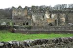
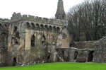
additions over subsequent centuries are very apparent. Also in view as we approach the  Cathedral is the ruined Bishop’s Palace. It would have been spectacularly beautiful back in its day. I’ll show you more a bit later.
The left picture below shows Ginger entering the Cathedral from the underwhelming south side entrance, the “Porch”, which leads you to one side of the nave. It’s today’s entrance, but I rather suspect that the original – or at least intended – entrance was the more impressive west entrance, shown in the right picture below. I say that not only because the


west entrance is so much more impressive, but because it gives a frontal entry into the nave; and the nave, the oldest surviving part of the cathedral (1100’s), is stunning when viewed from the back, as shown in the left picture below. It’s built in Transitional Norman style (ie, they experimented with some pointed arches). Originally the nave had no seats.


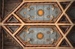
The pulpitum, the stone screen shown at the back of the nave, separates the chancel (domain of the clergy) from the common people and is from the 1300’s. A detail of that screen is shown in the right picture; it’s also gorgeous. This nave is so very different from your usual Norman cathedral (for an example, see post Durham and its Norman Cathedral). It is also spectacularly beautiful (in the nave picture above, ignore the raindrop on my lens, smudging the organ). The impressive Norman arches marching down the nave are each carved in a different pattern. However, what really gets the WOW! effect is that surprising ceiling. Yeah, maybe it doesn’t quite fit – the oak ceiling is from the 1500’s and is anything but Norman; it’s in 3D, ornately carved, maybe even frilly – yet it’s still stunning. Somehow the combination works, perhaps because the arches in the ceiling mimic the stone arches. Details of the ceiling are shown below.


 The layout of the Cathedral, shown here, is from a survey of the main part of the Cathedral in 1715; missing from the survey is the cloister and associated buildings. Beyond the nave the survey shows a number of rooms and chapels that were added later (as mentioned earlier).
We’re off to see these additions. Each is beautiful, and, surprisingly, each of them has a radically different floor and ceiling design! Below are some of the different floor patterns
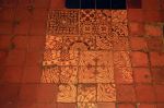


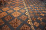
with their ancient tiles; some floors are intact and complete, others are made with restored pieces.
Leaving the nave, we enter the choir. The pictures below look back through the pulpitum into the nave. The murals are remnants of an earlier screen from the 1100’s.


Now the choir! It was built from the late 1400’s into the 1500’s. It’s a very open structure, as shown below, with some very nice wood carving (we’ll come back to that 3rd picture
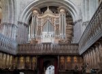


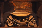
later). The nicely carved misericords (“mercy seats”, discussed in the post The Lincoln Cathedral) are from the 1500’s; a few examples are shown below. At the edge of the choir is the carved Bishop’s Throne, where the Bishop sits when officiating special ceremonies.


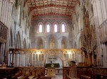
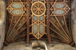
OK, now we’re going to look up, into the Cathedral’s tower. Wow. It’s gorgeous. The


back end of the choir looks into the high altar, as shown previously in the pictures of the choir (3rd picture). The high alter is really impressive!


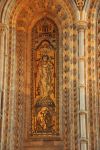
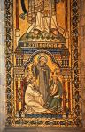
The mosaics behind the alter are exquisite.


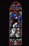
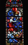
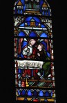
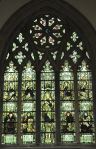
The stained glass windows are beautiful.

And then there’s that incredible ceiling. This area is soooooo impressive!
")


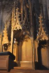
There are a few more chapels to show. The pictures below show the south aisle and, at its end, the Chapel of St. Edward. That roof is only from the early 1900’s; the original had


fallen into disrepair after Cromwall’s troops had stripped its lead in 1648. Behind the High Altar is the Holy Trinity Chapel with fabulous fan vaulting, shown in the left image


above; the right picture shows the very interesting ceiling of St. Andrew’s Chapel that you glimpsed earlier from the choir.  There are two more chapels. The Chapel of St. Thomas Becket, shown here, was built in the early 1200’s but remodeled in the 1300’s (the ceiling is from the 1300’s). In the layout schematic of 1715 shown earlier, this room is called “The Chapter House”.
The remaining chapel, St. Mary’s, is shown below. It was originally constructed in the late 1200’s, modified in the 1300’s, and a vaulted roof added in the 1500’s. Cromwell stripped away the lead roof in the 1600’s, leading to the collapse of the vaulted ceiling in the 1700’s. It was restored in the 1900’s. In spite of its travails, the chapel’s many medieval features have been preserved.


I’ll finish the Cathedral with the cloister, mostly for completeness; it’s not very exciting.


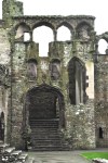
Just beyond the Cathedral are the impressive ruins of the Bishop’s Palace. It must have been quite beautiful.


Alas, the weather does not change from rain and strong winds, and there is no respite in sight. So our desire to hike the Coastal Path of Wales will be unrequited. Too bad! We think it would have been fabulous. Next lifetime?
 This last picture is us leaving Wales across the very beautiful bridge that connects to England. It’s still raining.
Next post – England’s Peak District.


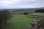
 clear that farming is a big deal here. It’s also clear that the Welsh have a very dry sense of humor – that or they’re incredibly anal, as suggested by this sign at the edge of the road.