Why visit Lincoln, you ask? This backwater city of 100,000? It’s not on most tourist’s maps, but the city was important historically. It has an amazing cathedral (English Gothic, 12th century), a castle (Norman, 11th century), a medieval Bishop’s Palace (12th century), one of only 4 original copies of the Magna Carta, a Christmas market and an annual Steampunk Festival, so it does get some tourists. More pertinent to us, however, is that it is home to younger son Britt and family, and we can visit! And visit. And visit. Little did poor Britt know that we would be there for an extended time. After Ginger and I left to visit Barcelona (Spain), I separated my shoulder trying to tackle a would-be camera thief on marble stairs (a topic for a future Barcelona post), so back to Lincoln we went to recover. There I fell and broke (badly) 2 ribs, and as I was recovering, Ginger needed major abdominal surgery. So we basically moved into Britt’s house for quite a while. Newly recovered and off to Wales, I slipped in a castle stairwell and broke two fingers (badly; spiral fractures); so back to Britt’s we went. Soooooo – let me show you some of Lincoln! It’s actually a very interesting town.

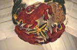
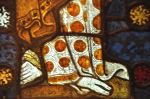
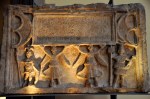
The Celtic Witham Shield
First some Lincoln history – and there’s lots of it. We’ll ignore the early part, such as the arrival of Homo heidelbergensis (500,000 years ago) or the Neanderthals a bit later (Europe has HISTORY!). Lincoln the city began as an Iron Age settlement of round wooden dwellings in the first century BC, established at a river (Witham) by a deep pool (Brayford Pool) at the foot of a large hill. The origin of the name “Lincoln” likely comes from Celtic for pool, Lindon. After the Romans conquered this part of Britain in AD 48 (using 40-50,000 soldiers), they built a fort on top of the (steep!) hill overlooking this settlement and at the northernmost end of the Roman road (Fosse Way) that went across England all the way to its southwest peninsula.


, about 200 AD")
With two rivers accessible from the sea, the settlement flourished; when the Romans left, the city waned until the arrival of the Vikings, under whom it became an overseas trading center. In the late 800’s, with an influx of Danes, Lincoln’s economy took off. In 1068, after the Norman conquest, William I (The Conquerer) ordered Lincoln Castle to be built on the site of the Roman fort, for the same strategic reasons as the Romans. Four years


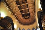
later he ordered a cathedral to be built, completed in 1092. Subsequently the diocese of Lincoln grew to became the largest in England, with more monasteries than the rest of the country put together. By 1150 Lincoln was one of the wealthiest towns in England and soon became its 3rd largest city, with an economy based on cloth and wool (known especially for their scarlet and green cloth; Robin Hood wore woolens of Lincoln green). In 2014, English barons rebelled over high taxes spent on King John’s failed wars in France and his arbitrary exercise of power. The Archbishop of Canterbury (plus a Lincoln bishop) was appointed to organize peace talks, leading to the Magna Carta; when that document was repudiated, the rebel barons aligned with France and the First Barons’ War began, a dynastic war for the throne of England. The turning point in this war was the Battle of Lincoln in 1217. The French forces of Louis VIII breached Lincoln’s city walls and occupied the city, but English loyalists successfully held the castle. The arrival of a loyalist relief force subsequently overwhelmed the French (and pillaged Lincoln on the pretense that the town was loyal to the French). After the French tried to replenish their forces but were defeated at sea, Louis VIII signed the treaty of Lanbeth, relinquishing his claim to the English throne. Lincoln’s fortune thereafter continually declined, particularly in the 1500’s after Henry VIII’s Dissolution of the Monasteries cut off a major source of income. Buildings were destroyed in the 1600’s when Lincoln was caught between factions during the English Civil War. In the late 1700’s, however, with the arrival of railroad links and the Industrial Revolution, Lincoln bloomed again. During WWI Lincoln invented, designed and built the world’s first tanks.
So enough history! Let me show you some of Lincoln, starting with it’s Roman heritage. A cool thing about Lincoln is that a lot of its major roads still go through Roman or medieval gates. Newport gate, shown below, was the walled city’s north gate in the 3rd century.


A few sections of the Roman wall and foundations of its towers are still present.


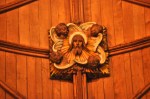
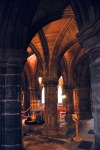
The Lincoln Cathedral had its own walled perimeter, or close, and some of those walls and a number of gates remain as well.


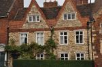
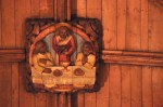
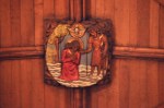
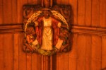
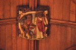
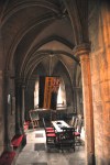
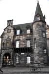
Lincoln’s allure lies less with its Roman ruins than with its medieval heritage, not just its castle and cathedral but also its medieval buildings (and a few streets). For instance, of the 3 buildings in the first picture below, take a look at the timbered building on the far right. Gravity has not been kind to this house – it’s called “The Crooked House” for good reason!


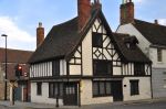
The oldest buildings in Lincoln date from the mid 1100’s and are associated with the Jewish community in Lincoln (before they were expelled en mass in 1290). The Jew’s House shown in the first 2 pictures below is one of the earliest town houses in England, built from local limestone in the Norman (Romanesque) style and dating from about 1150. Part of the façade survives; the elaborately carved doorway, the remains of two

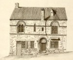

double-arch windows, and much of the stonework on the upper story. Next door is the Jew’s Court building, dating between 1150 and 1180, although the medieval stonework is mostly at basement level. It was originally built as a duplex.
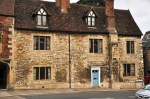
The Norman House, formerly known as “Aaron the Jew’s House”, dates between 1170 and 1180 and is another example of Norman domestic architecture. I do love the way


the stone intercalates with the brick of the adjacent building.
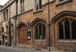
Another interesting building/gate is the Lincoln Guildhall and Stonebow. The Stonebow arch is located where the southern gate to the old Roman city once stood. The Tudor Guildhall, finished in 1520, was built on top; in the medieval period the Lincoln guilds met here to administer the city government. The pictures below show the front and back.


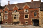
Other interesting houses are a merchant’s house of 1543 – the Leigh-Pemberton House (now the tourist office), and timbered shops (including the fabulous Stokes High Bridge Cafe) built on the west side of the High Bridge in 1540. The High Bridge was built over


the River Witham about 1160 and is the only medieval bridge in England with houses still on it.
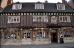
There are many, many other interesting buildings in Lincoln, and I’m showing just a few in the pictures below. In the first picture note the filled arch in the middle of the building (left of the blue door)! Such reworked facades are common.
Alas, I neglected to take pictures of some of the really cute bars in old houses along the river (who takes a camera to a bar?).
I’ll finish this post on Lincoln with a description of Steep Hill. The 4th picture at the beginning of this post is the city plan of Roman London, which shows an “uptown” (the Roman fort) and “downtown” (the associated city); and that plan is not too different from the structure of Lincoln over the ensuing 2ooo years. Uptown, at the top of a steep hill, was the location of the castle, the cathedral, and the rich and powerful. Downtown was everybody else. Connecting them then and now is a main shopping street (High Street, downtown) that becomes a medieval street called Steep Hill, lined with cute shops and restaurants. The Jew’s House, the Norman House, the Guildhall and Stokes are on those streets. The pictures below show the upper part of Steep Hill heading downtown


(gentle slope). The following pictures show a middle section of Steep Hill (and also the Harding House, from the 1400 and 1500’s). It’s hard to capture steepness in a photo, but


the upper right picture showing pedestrians walking ahead of me gives you a good idea. And that’s not the steep part! The really steep part begins where the road veers to the right (and drops out of sight), shown in that last night picture. Alas, I don’t have a picture of the steep part so I had to crib one from the internet, left picture below. Again, its


steepness is hard to capture in the photo; it’s steep enough to merit a handrail, as well as park benches for the out-of-shape to avoid cardiac arrest. You can buy t-shirts that say “I survived Steep Hill”. The last picture is from further down Steep Hill – why, it’s almost level!
Guess that’s enough introduction to the city of Lincoln. An interesting place, yes? And you haven’t seen anything yet. Next post will be about the fabulous Lincoln Cathedral.
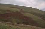
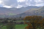
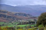
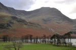
 this pristine area juxtaposes a lush green countryside with treeless hills reminiscent of the Scottish highlands – quite a fascinating mix! However, getting that lush green comes at a cost; rain, mixed with occasional “bright spots”. Alas, the pictures below should show brilliant colors (it was fall when we were there), but “gloom” and “brilliant” don’t coexist easily. Still, there were occasional bright spots like that shown above – which, by the way, was absolutely spectacular, in spite of the gloom!
 the earliest stone circles in Britain and possibly in Europe. From that aerial picture, it contains an unusual rectangular inclusion, called the “sanctuary”. You may recall our previous encounters with similar stone circles in Scotland and Ireland (


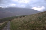


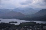


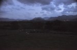
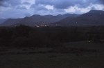
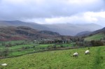
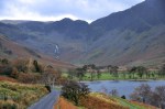
 picture isn’t shining on us. Today we’re driving a loop that goes through a lot of Lake District scenery: Newlands Valley, Buttermere Village, the Honister Pass, Borrowdale, and Derwentwater Lake. We’re heading west, and our two-lane road quickly becomes a single lane, as shown in the first picture below (although the road does have turnouts). The subsequent pictures show picture-book idyllic scenery.
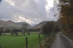


")


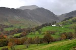
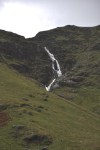
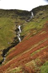
 We’re now heading up to glacier-carved Honister Pass. This picture also looks back at our previous waterfall, far in the distance. The river adds a new element to this pretty area.


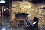
 This house, the oldest in Glasgow, was built by (and near) the Glasgow Cathedral in 1471. It likely reflects “the lifestyles of the rich and famous” for that time. It was originally the home of one of the 32 canons who managed a part of the Cathedral’s vast diocese – in this case the land at Provan (the other 31 canons were similarly housed). By the 1600’s it had become a private home; by the 1700’s, and for the next 200 years, it was used as an inn, with rooms on the upper floors and a wide range of shops on the ground floor. A small extension housed the city’s hangman. It’s a pretty cool place, all stone with massive, rough-hewn, low-hanging beams and fireplaces everywhere. The entrance opens into the
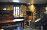


 the unconquered north, in AD 142 Hadrian’s successor Emperor Antoninus Pius ordered a new wall built about 70 miles further north of the existing wall. Again these clever Romans somehow knew where the shortest distance would be, and the wall was built from the river Clyde just above present-day Glasgow to the Firth of Forth just west of present-day Edinburgh. The wall was 39 miles long, about 13 feet high, and 16 feet wide; it took 12 years to complete. It was built of turf and earth on a stone foundation. Like Hadrian’s Wall it had a deep ditch on the north side and a military road on the south. A wooden palisade is thought to have been on top. It was protected by 17 forts with about 10
 “fortlets”, very likely on (Roman) mile spacings. In spite of the effort it took to build the wall, it was abandoned only 8 years after completion (162 AD), the garrisons being relocated back to Hadrian’s Wall. Following a series of attacks in 197 AD, the emperor Septimius Severus arrived in Scotland in 208 to secure the frontier. He ordered repairs and re-established legions at Antonine’s Wall (after which the wall also became known as the Severan Wall). Only a few years later the wall was abandoned for the second time and never fortified again.


; water would have flowed from her middle to a basin")

