To go from the east coast to the west coast on the South Island, one has to deal with the Southern Alps that run down the spine of the South Island. There are only 3 roads that make the crossing; we’re taking the highest one, via Arthur’s Pass. Now that I’ve done that build-up, let me confess: it really doesn’t go that high. The pass is just a little shy of 3000 ft. Goodness! Of course the road does start from sea level, but c’mon. No gasping for oxygen in thin air like the passes in Colorado, where you’re cold even in July. In NZ’s defense, this is not their high peak region; maybe it makes some sense to build cross roads where the mountains aren’t so tall?
We’re heading “home” to our rented house at Ruby Bay near Nelson. Time for a break from traveling. To get there we’ll travel along the west coast, but first we have to jump the hump. The road up is actually rather gentle without excessive turns; Ginger was a bit apprehensive given our experience going over mountains to Golden Bay (post “Abel Tasman National Park and Golden Bay”, Dec 30).
Hmm. Let me diverge here and give some context on driving in NZ. In addition to NZ’s aversion to a straight road, and in addition to everyone driving on the wrong side, there are other aspects to driving a car here that make it interesting. For instance, the solid yellow line down the middle of the road that says you better not pass? Those lines seem to be applied pretty much at random, and not very often. One should never ever ever think that the dotted line here means it is safe to pass! Dotted lines frequently go around blind  curves. “Frequently” as in usually. I trust my eyes only, and I avoid passing except at marked passing lanes. Another example is NZ’s frequent use of one-lane bridges; some are more interesting than others, such as the one to the left: like the others, it’s only one lane, but unlike the others, it is also used by trains – those are railroad tracks down the middle! How does that work??! Finally, most roads here are 2-lane, bi-directional, usually narrower than back home, and with little or no berm; and like the US, most freight goes by truck. However, here
 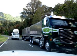 that means semi’s whiz past a couple feet away (feels like inches), at top speed; the wind-blast alone is slightly unsettling. But it all seems to work (no crashes yet!).
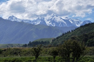
OK, back to my story. Initially the land around us is rather pastoral; we are not hemmed in by towering mountains. The view reminds me of the cattle regions of Colorado and Wyoming, with mountains in the distance and the cows up close. When the mountains do come to meet us, they appear
older and weathered, as shown above. Hey, speaking of older and weathered, Ginger sneaks in a picture of me! The mountains are covered in scree – a bitch to climb, probably. They’re not exactly majestic, these mountains, but to this mountain-loving guy, they are beautiful. As we go further, however, the mountains start to get  bigger and more impressive, as shown here. The road at the bottom of the picture provides perspective. Not bad, eh? Glaciers eons ago carved up these puppies, and we appreciate all that hard work.
We come to a river plain that we must cross, and it is spectacularly beautiful (and photogenic, may I add). The river is an impossible turquoise, obviously glacier-fed, but light glinting from the sun and reflections from the sky make it silver or blue depending on where you’re looking. We stop to stare, and I take a lot of pictures, which I will foist on you. The lupine is everywhere, creating a riot of color. Wow. Look at that river color and the mountains and the lupine. Hope you enjoy it as much as we did.
We’re staying in the (very) little town of (of course) Arthur’s Pass, which is very close to the top. It’s around 5pm, so we have time for a quick hike. There’s one nearby called Devils Punchbowl, listed as short but steep. Short is good, but Ginger is not sure she wants steep; I push, so off we go. Very quickly we see that this should be a nice hike! After a short walk to a suspension bridge, a gorgeous waterfall is visible off in the distance, and undoubtedly that’s where the trail is going. I’m excited! As we get closer, it really is a fabulous waterfall, as seen in the right picture. The water is falling in beautiful sprays,
and the rainbow moves around. The trail disappears into the woods and becomes quite steep. Perhaps in the picture below right you can see that there is a wooden staircase at the end of the rock steps? I’m not used to stairs on a hiking trail; the commitment to good trails in NZ (Dept of Conservation) is impressive. Ginger, however, is not a fan of stairs
on a trail, particularly when the risers are not consistent – her arthritic hips complain – and she tells the DOC, just in case they’re listening, what they can do with their stairs. She’s actually not sure she wants to go on, and tells me to go ahead, she’ll make up her mind after resting. So off I go. When I emerge from the forest,  the waterfall is right there and does not disappoint. It’s really two falls, an upper and lower, as shown. It’s not possible to get both in the camera frame. It’s also really hard to photograph – the trail goes to a wood platform that’s built out over the river, which I’m standing on, but the spray is blowing right into me, and I’m getting soaked. I take a picture, retreat, wipe off the lens, and repeat. I feel like a shampoo ad. The rainbow moves around with the spray, and goes bright and dim, but it is always there. It’s gorgeous, and I wish Ginger could see it. I start back down the trail, and lo! Ginger is here! She made it! We marvel at the beauty together, and she asks whether I’ve noticed that the mist is soaking us. Eh? Speak louder, I have water in my ears. Time to go back before they stop serving dinner. Ginger counts the stairs on the way down – 352 each way, she tells me. But it’s worth it, right? I say, ducking just in case. Below are a few more pictures of the falls.
 Back at our (rustic) lodge I take a picture of the mountains above us as the sun is setting. Hmm. OK, maybe I was wrong earlier about these mountains; majestic does apply here. It’s an impressive view, and a challenging chunk of rock.
I also see a Kea, the world’s only alpine parrot and  reputedly the most intelligent and entertaining bird on the planet. It has an inexhaustible curiosity, which leads to mischievous behavior. Examples, we are told, are pulling the nails holding corrugated-iron roofing on, eating rubber windshield wipers off of cars, or turning hiker’s boots into a pile of leather strips and shredded laces. Their cuteness and curiosity and intelligence means they quickly learn how to play to the tourists, but being fed by tourists is also leading to their demise, as they lose the ability to forage for themselves in winter and they are drawn to the dangerous roads. Total Kea population is about 1-5 thousand birds.
The next day, as we continue westward, we decide to do the short Beasley Valley Track, which goes to the Beasley Chasm, touted for its river cascading over huge boulders and for its views of Mt. Rolleston. It is a nice hike, as the pictures below show: nice river, nice mountain views, and pretty flowers.
We travel further to the Dobson Nature Walk, right next to the highest point of Arthur’s Pass. The Nature Walk is short, highlighting subalpine and alpine plants. It’s a loop, climbing up a hillside, and except for the stream at the bottom, it’s very dry. It does have a good variety of flowers (most of which we can’t identify), but not in great profusion. Pictures below:
We go for a final hike, the Otira Valley Track. It follows the Otira River up a deep valley on the north side of Mt Rolleston. Ginger decides she has had enough hiking, thank you, and is gracious enough to wait while I do it (estimated time is 1.5 hours). The trail is mostly up, but it isn’t terribly steep. It is, however, quite tricky; lots of rocks protrude, or you’re crossing scree, or the trail is practically hidden in vegetation, with (unseen) sharp drop-offs to the side. Also, there are a lot of small waterfalls streaming down the
mountain side and then snaking their way to the river – across the path. Crossing these small creeks is a bit tricky in parts, tiptoeing across rocks in a narrow path, and sometimes the streams are even hidden beneath the vegetation until you’ve stepped in them. Thank you Gortex! The trail is a good test of balance (which, I note, is not as good as it once was). This effort is rewarded by nice views. Initially you’re above the pretty, if small, Otira river, but then the trail comes down to it and its delightful happy music. Pictures below.
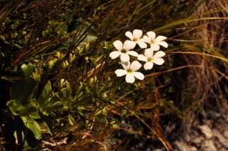
There is a lot of water everywhere, including underfoot. As a result, there are also a whole lot of gorgeous flowers everywhere. Most of them I showed you earlier on the Dobson Nature Walk, but the picture to the left is just too pretty not to include. I was actually looking for the white mountain orchid, which a couple ladies coming down the trail were excited about seeing. Of course I have no idea what the orchid looks like, and, hopeful, I take pictures of a couple of new stalked flowers – but no, I missed it. The stalked flowers
are shown above. I do want to show some additional pictures of the Mt. Cook Lilly, which you saw earlier but which are plentiful and beautiful. They’re big, and mis-named: they’re really the largest member of the buttercup family. Let me tell you, it’s hard to believe that! They have nothing in common with a buttercup that I can see! You can find both kinds of buttercups here (yellow buttercups shown on the Dobson Walk), but the Mt. Cook Lilly is truly magnificent, as shown below.
They can grow to be 3 feet tall. The plants are also interesting in their evolutionary adaptation to this harsh environment. Like all plants they have stomata in their leaves for transpiration, which in other plants are on the cooler, shaded underside of the leaf to avoid too much water loss. However, since the Mount Cook lily grows among rocks which heat up during the day, the underside of its leaves are often warmer; so it has stomata on both surfaces of its leaves. It closes the lower stomata when the rocks warm up, opening the upper ones to the cool air, and then reverses the process at the end of the day. Pretty smart for a pretty plant.
The footbridge across the Otira, shown earlier, is officially the end of the trail. However, I’ve gotten here early and the view going forward is  compelling, as shown below, and I decide to go a little further. Further is across a huge scree bed, with large and very loose stones, so it’s difficult going and not without some danger of spraining an ankle. Small scree is like big sand and you can just walk (and slide) across. You kind of have to tack. The big scree is a different matter; it’s as much hole as it is rock, and you have to test each stone before putting weight on it. So going is slow. Too slow! I travel a bunch, and that
  compelling view has not changed much, as you can see! It would be nice to see around the bend, but it isn’t going to happen, I’m out of time. So back I go, with a pretty view in the homeward direction as well, as shown in the images below. A good climb!
Ginger has been very patient in the hot sun-blasted car without water (I took it with me) – so I give her a big kiss (and the rest of my water). Thanks, sweetie!


