ISLE OF SKYE
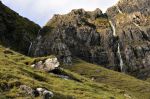
The word “skye” means “cloudy” in Old Norse, and for those not familiar with Old Norse, this island is also fondly known as “The Misty Isle”. We did experience its namesake conditions, but we were lucky; the weather was good most of the time. The island is gorgeous, atmospheric and dramatic, with stark mini-mountains dotting the landscape. Although the island is large, the shoreline has many lobes that jut out into the sea; no spot is more than 5 miles from a beach. Even better, with the mountainous mainland nearby (previous post), and a number of small islands scattered offshore, views off to sea are pretty awesome. Below are pictures from our drive into Skye.
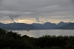


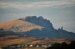
That last picture is the view from our B&B; off in the distance is the Old Man of Storr; we’ll visit it tomorrow.
THE TROTTERNISH PENINSULA
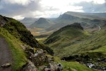
We’re going to do a circuit around one of the island’s loops, the Trotternish Peninsula, which sports a rugged, unique landscape formed by massive landslides thousands of years ago. Our first stop is The Storr, the highest  (2400 ft) mini-mountain on this peninsula, anchoring the southern end of the Trotternish Ridge. In particular we’re visiting the Old Man of Storr, that little spike of rock on the right side of this picture. During the landslides, the Old Man landed on its end; after much weathering it’s still a 160 ft high vertical chunk of stone. This picture of the Storr, by the way, is from a different day that was sunny. Today it’s overcast and gloomy, as you can see in the pictures below. However, even in these misty


clouds The Storr is a strikingly beautiful sight – and The Old Man is pretty impressive.
Traveling further, we are treated to beautiful views that combine the sea, off-shore islands and mainland. The mountains behind us aren’t bad either.


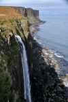
A bit further we come to ruins of an old tannery (below), abandoned during the Highland Clearances that began in the 1800’s; many residents were forced off the island by aristocratic landowners who wanted more room for their livestock. Nearby is Kilt Rock, a 200 ft cliff; its vertical lava columns look like pleats on a skirt, and paired with those horizontal striations, it resembles a kilt. There’s also the spectacular Mealt Waterfall doing its lemming thing off the cliff. The views are awesome.


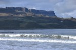
For a change of pace, we dip down to stroll on the beach at Staffin Bay. It’s a pretty place.


Next we take an inland road to Quirang, a name from the Gaelic for “pillared enclosure”. The road rises steeply, and we’re now at the upper end of the Trotternish Ridge. The view is stunning, and we decide to investigate further by hiking the trail that starts from the road. The trail is a loop, about 6 miles long but with 1400 feet of climb, and we’re not


at all sure we’ll do it all, since time (sunlight) and effort are an issue. We think we’ll go at least to that center rock formation in the right image (above), called “The Prison”, and look over the edge to see what we can see. As we walk, the views to our right become
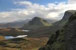

increasingly stunning, as shown above. Alas, we will not make it to The Prison. It’s not an easy trail. From the first and last pictures just above, you will note that we’re on a really, really steep hillside – sometimes disconcertingly steep. Worse, parts of the trail are quite difficult to navigate, particularly where the water flowing from those waterfalls cuts though the trail, requiring a transition from hiking to (wet) rock climbing over a crevice.


Those traverses are tough, and after doing the first one, Ginger decides she has had enough and heads back. I decide to push on to The Prison, but after awhile I realize it’s further than it looks, and I too turn back. The view going back is just spectacular, as you can see below. Note to self – do this loop hike another day! It’s too pretty to miss!


Near the tip of the peninsula are the crumbling remains of Duntulm Castle (below), built in the 1300’s and 1400’s when the area was subject to feuds between rival MacLeod and


MacDonald clans. In the 1600’s the castle was the seat of the chiefs of Clan MacDonald. It was abandoned in 1732 when the MacDonalds built a new castle further south on Skye (taking much of this castle’s stone for the new one). As shown below, the mountains are still gorgeous even way out here near the peninsula tip.


A bit further on, we encounter the Skye Museum of Island Life consisting of several thatched stone huts, some of them original (200+ yrs old), illustrating how a typical Skye family lived back then. Alas, the museum was just closing as we arrived. The largest hut, The Old Croft House shown below, consists of 3 rooms: a kitchen, also serving as the main


living area (where a peat fire would be lit every minute of the year); the parents’ bedroom off the kitchen; and beyond that the children’s bedroom (for as many as 12 kids). Note the clever design; the stones that hang from the roof keep the thatch from blowing away, and the edges of the buildings are curved to redirect the wind.
 We’re nearing the end of the loop, here looking back at the village of Uig. Note, near the center of the image, the parallel strips of land with a house at the top. In the old days the land was owned by Scottish clans or English aristocrats who divided it into these crofts and rented it to tenant farmers who eked out a bare living. Today they’re privately owned plots, but their history is still visible.
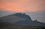
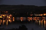
Back at our B&B, I take a few final shots of The Storr as evening sets in, and then a couple of night shots of the nearby city of Portree and its Loch.

Next post: Isle of Skye II – Fairy Glen, Dunvegan, and The Cuillin Hills.

[…] that bit of the Quiraing hike we took in the Skye I post was pretty fabulous (Isle of Skye I – The Trotternish Peninsula), I’m off to do the entire loop hike, expecting great things. However, the trail has some […]
This was a llovely blog post