Because that bit of the Quiraing hike we took in the Skye I post was pretty fabulous (Isle of Skye I – The Trotternish Peninsula), I’m off to do the entire loop hike, expecting great things. However, the trail has some pretty tough parts as we discovered in Round I, so Ginger is having none of this adventure and is opting for R&R.
 This morning I’m greeted by the Sgùrr nan Gillean peak looking quite spiffy. It would be fun to climb that beast, but not this trip; I kinda doubt it’s a day hike, plus there would be mutiny.
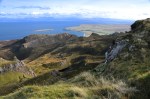
The trip back to the Trotternish Peninsula is picturesque, with views of Raasay Island and behind it the mainland (below).


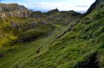
Here we are, and off I go. You’ll perhaps recall this stunning scenery that one sees immediately at the trail start. No long walk to the pretty parts here!


I want you to remember that long wall of cliff-face rock off to the left in the images above. It’s impressive, but there is more to the story that I’ll come back to later. The view ahead is gorgeous, but the view to the right is dazzling, as you may recall.


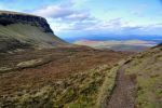
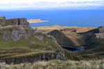
Those mountains are the Trotternish Ridge, receding into the distance. OK, time for new territory! I’m now where no Warner has gone before, making it to The Prison (many of the


rock formations have names). Now over the ridge – and it’s beautiful. That’s probably the


Outer Hebrides (islands) there in the distance, which we will be visiting. The view on the left is all rock cliff, imposingly close, as shown below. That thin vertical rock formation in


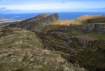
 the first picture above is called “The Needle”. As you can see in the other two pictures, we’re following the cliff wall to new mini-mountains up ahead. The trail is easy enough but it’s narrow, and occasionally when the hillside is quite steep, the downhill edges of the trail become a bit unstable. The trail shown in the left picture is less than a foot wide; walking across it is not unlike walking a gymnast’s balance beam, with consequences for slipping off.
The trail continues counter-clockwise around the rock cliff, and I’m in the shadow of that cliff surrounded by a jumbled but interesting terrain – and a nice spot for a lunch break.


The trial rounds the bend and starts steeply up – below is rock cliff, above is grassy slope. Then, Voila! – I’m through a notch, and turning left I’m at the base of a huge ridge.

Really it’s more like a very long sloping plateau; this is where the trail starts to loop back. The trail heads to the top of the cliff and continues along the cliff edge. Before long I reach a spot where I can look down and see where I ate lunch. From here, the combination of mountain, lake, sea, island and rock create views that are amazing, as shown in the first two pictures below. They were taken while standing in the same spot, the second one
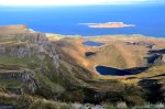
turned 90°. Wish I had taken the 360! Even better, the higher you hike up that sloping plateau, the more awesome the views become (last picture above).
 I love this picture! The view is fabulous, but it also helps you appreciate the huge “sloping plateau” I’m on, which is very much like one to the far right in this picture, but much bigger.
A surprising observation is that, in spite of the plateau’s steep slope and the lack of rain today, the ground is a marsh, even near the top! I’m trying to walk on clumps of grass to keep my feet dry. If the ground is usually that wet, it might help explain the relatively low diversity of plant life.
 I’ve finally reached the top; this high up, there’s a commanding view, shown on the left.
There’s not much of a trail anymore. As I continue along the edge of the cliff, I’m surprised to discover that I’m not on the cliff I thought I was on. In front of and some distance below me is a secluded green plateau that’s hidden from the first part of the trail by vertical rocky projections. Those projections are the back side of the long rock cliff the trail followed at the beginning of this hike – it’s a cliff in front of the cliff I’m on! The secluded plateau is called “The Table”, and I discover later that


“Quiraing” is from Gaelic (“cuith raing”) meaning “a pillared enclosure”. It is that! I’d like a better picture of the Table, but the ground slopes down ever more steeply toward the cliff edge. So, discretion being the better part of valor, I’ll have to be satisfied with the pictures above. Besides, Ginger would kill me if I slipped over the edge!
It’s pretty up here, as shown below. The two hikers in the first picture below should


provide some perspective. Distance and height are greater than they seem.
Finally, a last view from on high, looking down the Trotternish Ridge. Impressive, isn’t it? A spectacular finish to a spectacular hike. That last picture shows the trailhead parking


lot at the far right. Still a ways to go, bushwhacking down the mountainside.
Hope you enjoyed this long description of the Quiraing Loop. As you can tell, I certainly did.
Next post: Isle of Skye IV, Strath and the Sleat Peninsula
